


Alleghany County Map

Image: University of North Carolina Press
Alleghany County Quick Facts
Population (2014 census estimate): 10,879
Land Area (square miles): 235
County Website: alleghanycounty-nc.gov
Places and Things in Alleghany County:
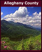
Alleghany County shares its northern border with Virginia. Most of the county is located on a rolling plateau at approximately 2,700 feet above sea level. The plateau is crossed by numerous hills and mountains with Peach Bottom Mountain being the highest point at 4,175 feet. There are two major rivers: the New River and the Little River. The Blue Ridge Parkway passes through the middle of county just east of Sparta, the county seat. Doughton Park and the Blue Ridge Music Center are major attractions along the Parkway in the area.
Alleghany County enjoys considerably cooler summers than the lowland areas to the east and south, with temperatures rarely rising over 85 °F. In the winter, due to the high elevation, temperatures can fall into the teens or lower, and snowfall can be very heavy at times.
A Brief History of Alleghany County
Places in the County on the National Historic Register
Cities, Towns and Communities:
Sparta (county seat) - zipcode: 28675
More Alleghany County Information:
Weather and Detailed County Map
Rural Electric Service or Duke Power
Telephone Service
Cable Service
Water & Sewer provided by local muncipality or private well and septic system
Parks:
Parks and Recreation Department
Doughton Park
New River State Park
Stone Mountain State Park
Blue Ridge Parkway
Fairs and Events:
Alleghany Fiddlers Convention
Christmas Crafts Fair
Mountain Heritage Festival
Alleghany County Fair
Adjacent Counties:
North - State of Virginia
South - Wilkes County, NC
East - Surry County, NC
West - Ashe County, NC